Our Company provides two GPS services:
-
What is GPS?
The Global Positioning System (GPS) is a network of 24 satellites (owned and operated by the United States Department of Defense) orbiting the Earth which, through the use of satellites and computers, is able to coordinate locations anywhere on Earth.
How Does GPS Work?
The GPS works through a system of triangulation (trilateration as some may say). In order to precisely pinpoint a location on Earth, the receiver must be “in view” of at least four satellites at the time of data collection. The receiver’s location is then pinpointed by way of trigonometrically comparing the distances from each satellite to the receiver. (Thankfully, the receiver does the calculating, not us!) The Trimble TDCI Asset Surveyor receiver used here at ICS is an 8-channel receiver, which has the ability of tracking up to 8 satellites at any given moment.
How Accurate is GPS?
An accurate position is calculated by using at least four satellites. However, the accuracy of positions calculated by a stand-alone receiver can be highly variable (at times up to variations of 100 meters). Therefore, correction methods are required in order to produce near-exact coordinates. This correction occurs through use of differential correction, which uses information from two receivers (the hand-held rover and a permanent station) to more accurately pinpoint a location. The two types of correction used here at ICS are “real-time” and “post-processing” correction.
Real-Time Correction:
Real-time correction processes the data as it is received from the satellites. Correction information broadcast from a reference receiver is used to correct the data on-site. The accuracy of coordinates produces in real-time ranges within 1.5 to 3 feet
Post-Processing Correction:
Post-processing corrections further correct the data collected on-site by interfacing information from a more static base station with the real-time corrected data. This is done by way of computer software. The accuracy of coordinates following post-processing correction is within 10″ to 20″.
Is There a Potential for Errors in the Data?
As with anything else, there is always a possibility for error. Fortunately, it is the sum of several errors that will ultimately diminish the accuracy of a GPS coordinate point. The key to obtaining accurate data is to minimize the number of errors occurring at any one time. Following is a list of some of those sources that occur often during GPS data collection and how they affect data accuracy along with methods of prevention:
Selective Availability:
The largest and most common source of error occurs due to intentional scrambling of the GPS signal by the Department of Defense. Position accuracy can be distorted by up to 100 meters 95% of the time. Fortunately, this is easily overcome by both real-time and post-processing differential correction.
Obstruction:
Environmental factors, such as trees or buildings can sometimes simply get in the way of signals. This is overcome by carefully planning when and where data collection will occur. Utilizing data collection periods when more satellites are directly above in the sky is a sure way to alleviate this problem.
Multipath:
Multipath errors occur when a signal is reflected off an object prior to it reaching the receiver. This results in a skewed distance computation from the satellite to the receiver. Accuracy of a reading due to such an occurrence is highly variable. Maintaining proper field techniques and receiver firmware can reduce its effects. Fortunately any major data flaws are easily recognizable during office processing and corrections can be made.
Satellite Coverage:
Finally, the more satellites “in view” the better. As the strength of satellite signals increases, so does the accuracy of data. Again ensuring the highest quality coordinate points is achievable through proper data collection planning and follow-through.
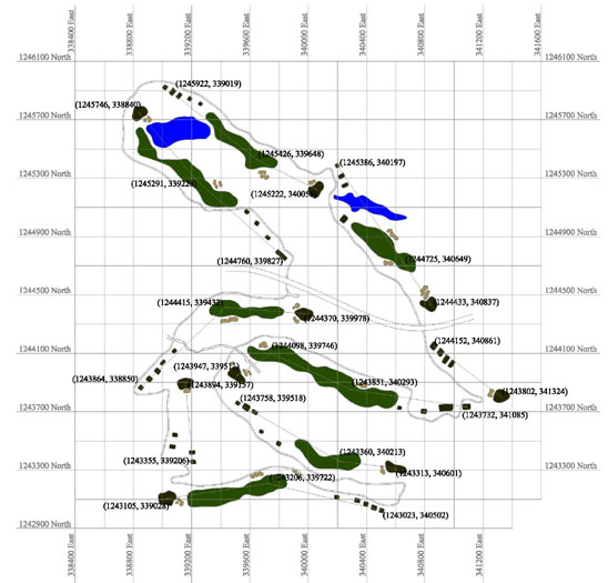
Here at ICS, GPS mapping is a matter attended to with much pride and seriousness. Data collection assignments are carefully planned and carried out. Information is collected when the time is right, not simply when it is possible. We have the ability to produce GPS maps for a variety of different irrigation needs. Whether it be for the location of valves or an entire irrigation layout, ICS has the ability to meet your GPS needs.
-
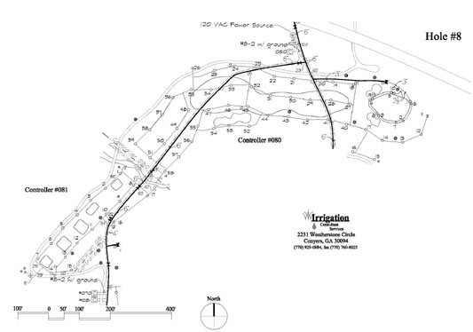
The irrigation central control system is linked with golf turf management system. Manufacturers in both industries agree that the satellite technology will greatly impact golf course management for the next millennium. The manufacturers’ research engineers and scientists are developing both software and hardware from space. These technological advances are having an impact on our nation’s agricultural and water management programs.
These programs currently monitor the temperature of plants, disease control, water consumption and the impact of water drainage on the natural environment. Toro’s Site-Pro, Rain Bird’s Maxi, and Hunter’s Vista system are all programs currently involved with these technological advances. John Deere and Textron will have related systems in the very near future.
Why GPS?
In order for these systems to work properly, the information sent from the satellites must be able to be directed towards a “real world” endpoint. Through GPS (Global Positioning System) mapping, this endpoint can be created. GPS mapping involves systematically pinpointing “real world” features on a “real world” coordinate system. There is no guess work involved with real GPS mapping. The map is not hand drawn with coordinates made up by the draftsman. Rather, the map is generated through an initial phase of on-field data collection by way of GPS surveying followed by computer generation of a map through the use of GIS software interfaced with Computer Aided Design software. The end result is a “real world” map, which when interfaced with the central control system and space satellite information allows the superintendent to precisely monitor all facets of his/her course management system.